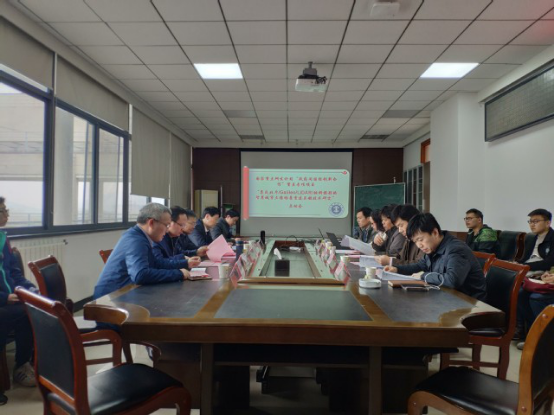
A glance of the Project Start-up Meeting
The launch of “The Research of Key Technologies of 3D Reconstruction to Smart City by Using the integrated Big Dipper’s slope photography of GalileoLiDar”, a key project of Inter-governmental International Innovation Cooperation under the National Key Research and Development Program of China, was hosted by Professor BianZhengfu of CUMT.
This strategic project, approved in 2019, is a key program of the inter-governmental technology and innovation cooperation between the Chinese government andthe government of Slovak Republic with China University of Mining and Technology as the lead institution. The project is headed by Professor Bianand is supported by Professor Vladimir Sedlak of the University of PavolJozefŠafárikin Slovakia.
The Project aims:
● To promote the integration of innovation of Big Dipper/Galileo/LiDarslope photography measurement and the construction of GNSS/INS/Image Position and Direction and LiDAR-the system of multi-granularity geospatial information fusion technology for camera images
● Tackle key problems and make breakthroughs in key technologiesof three-dimensional modeling
● Create representation of typical elements and scenes of smart cityand demonstrate applications in areas like smart community, public safety and fire control.
● Vigorously promote the innovation of relevant researches,the nurturing of talent and the development of international cooperation along the routes of the Belt and Road Initiative.
The project is supported by various stakeholders including Chen Zishen, the Vice-General Manager of ARSC Underground Space Technology Development Co. Ltd and Wang Xiaoqiang, the deputy director of the municipal Bureau of Natural Resources and Planning of Xuzhou.
The following schools and departments are integeral to the project:
● School of Environment Science & Spatial Informatics
● CUMT’s Academy of Science and Technology.
● Department of Surveying and Mapping and Geographic Information of the School of Environment Science & Spatial Informatic
Source: Zhang Qiuzhao and Zhang Yunyue from the School of Environment Science & Spatial Informatic
Photographer: Zhang Qiuzhao
Editor: Liu Zhunxu
Reviewer: XiongZhizhong